SC/53/E8
PRELIMINARY
REPORT ON IWC-SO GLOBEC COLLABORATIVE RESEARCH IN THE WESTERNANTARCTICPENINSULA
STUDY AREA MARCH JUNE 2001
1Marine
and Migratory Wildlife Ecology Group, School of Ecology and Environment,
Deakin University, GPO Box 423, Warrnambool, Victoria, Australia 3280
2Center
for Coastal Physical Oceanography, Crittenton Hall, Old Dominion University,
Norfolk, VA 23529, USA
3Duke
Marine Lab., Beaufort, North
Carolina, USA
4NOAA/National
Marine Fisheries Service, National Marine Mammal Laboratory, 7600 Sand
Point Way NE, Seattle, Washington 98115, USA
5 2535
Sky View Lane, Laramie, Wyoming82072, USA
Abstract
The
first three cruises in the year round Southern Ocean GLOBEC series for
2001-2002 were conducted from March June 2001. International Whaling
Commission researchers participated in all three cruises (Gould
LMG 01-03 USA
mooring cruise, Polarstern AntXVIII5b ship and helicopter based
studies Germany,
Nathaniel B Palmer NBP 01-03 USA
survey cruise). A combination of ship, zodiac and helicopter based visual
survey, tissue biopsy, and photo identification techniques were used on
the vessels by the IWC. Passive acoustic moorings and expendable sonobuoys
were deployed by the US
passive acoustic team. The most frequently recorded and abundant baleen
whale species in the study area were minke and humpback whales. An initial
overview of oceanographic data shows strong patterns of correlation between
autumn and early winter baleen whale distribution, the inshore cold Antarctic
coastal current, and upwelling of this cold water produced by intrusions
of the Antarctic Circumpolar Current into MargueriteBay.
Confirmation of krill autumn migration into inshore waters associated with
complex bathymetry (ie. dense aggregations in deep pools or holes) was
made on these surveys. This indicates that baleen whale prey is available
throughout all seasons. Baleen whales were observed in MargueriteBay
as late as June, and it is likely that both humpback and minke whales overwinter
in this region. These preliminary associations will be tested during the
winter NB Palmer cruise (July September) and through modelling
and analysis planned between IWC and SO GLOBEC in 2001. The 2002 series
of cruises will further test these and other physical and biological associations.
Note:
all figures/maps are in colour and are available from the Secretariat as
reference copies. A full set of images can be copied for individuals on
request.
Introduction
The International Whaling Commissions interest
in participating in international multidisciplinary research programs such
as CCAMLR and SO GLOBEC has been extensively documented in IWC Scientific
Committee reports, Resolutions of the Commission and papers (ie. SC/46/O18,
SC/47/O20, SC/50/Info.14, SC/52/E22). At IWC 51 plans for collaboration
on CCAMLR surveys in the Antarctic Peninsula
were developed for the 1999-2000 austral summer. These surveys were successfully
conducted and initial results were presented in SC/52/E21 (Reilly et
al 2000).. Detailed analysis of krill and
baleen whale data sets are currently being conducted by CCAMLR and IWC
scientists.
At IWC 52 preparations were made for participation
in the 2001 2002 year round series of SO GLOBEC survey and process
cruises. A budget was developed to include purchase of essential equipment;
participation by Thiele (IWC-SO GLOBEC steering group Chair) in planning
meetings and relevant GLOBEC workshops; and to fund IWC participation in
the initial cruises planned for March June 2001. Due to urgent funding
requirements for the POLLUTION 2000+ initiative, it was agreed at IWC 52
that funds for the IWC-SO GLOBEC collaboration would need to be limited
to equipment purchases and planning activities, with participation to be
delayed until after IWC53 unless funds could be acquired outside the IWC
SC budget. Thiele secured funding from the Australian Government to support
initial IWC participation in the first three SO GLOBEC cruises. Equipment
for the collaboration approved in the IWC 52 budget was purchased by the
IWC.Items of equipment not covered
in the IWC 52 budget were lent from Thieles SOCEP program. Although the
opportunity to biopsy appeared unlikely prior to the initial cruises, we
determined that it would be prudent to be prepared, and two sets of crossbows
with associated biopsy sampling gear were kindly contributed by the Southwest
Fisheries Science Center in return for any skin samples obtained. This
meant that participation by the IWC could begin in the first phase of the
program, and the opportunities provided by the substantial research effort
in the first half of 2001 would not be lost.
A range of national research programs had been identified,
some tentatively, to contribute to studies during 2001 2002 in the SO
GLOBEC study area. However, by far the greatest effort came from the US
National Science Foundation funded cruises. This effort includes five cruises
in 2001 in the austral autumn and winter, all of which will be repeated
at exactly the same time in 2002.
The overall goal of the US SO GLOBEC effort in this
study is to elucidate shelf circulation processes and their effect on sea
ice formation and Antarctic krill survivorship and availability to higher
trophic levels, including seals, penguins and whales (Hofmann et al
2000 draft plan in SC/52/E22 Appendix 1). The central Western Antarctic
Peninsula (WAP) continental shelf area is characterised by unusually high
krill production. The US SO GLOBEC research program structure has been
developed around a central hypothesis: that a unique combination of physical
and biological factors contribute to enhanced krill growth, reproduction,
recruitment and survivorship throughout the year in the central Western
Antarctic Peninsula (WAP) continental shelf area; and that in particular
this region provides physical conditions that are especially favourable
to winter survival of larval and adult krill.
The presence of krill predators in the study region,
particularly in winter, is central to the main hypothesis of the research
program. Seal and penguin studies are a strong component of the process
study cruises in the US
program. Clearly this program provided an unprecedented opportunity for
the IWC to obtain data and conduct multidisciplinary analyses towards its
objectives regarding associations between baleen whales, their prey and
the physical environment. SO GLOBEC will benefit from the collaboration
through an additional, and essential top predator component in their investigations
of the dynamics of krill in these ecosystems.
Berths for IWC visual surveys were provided on the
mooring cruise (L M Gould) and both survey cruises (NB Palmer)
by the passive acoustic team led by John Hildebrand. The IWC team and this
team have worked collaboratively throughout the US
surveys. Process study cruises on the L M Gould run simultaneously
with the N B Palmer survey cruises and although no berths were available
for IWC on the LMG process cruises, the seal teams on board were
trained to use Wincruz Antarctic by the IWC observers, and provided with
equipment to record cetaceans whilst on watch. This approach further increased
the cetacean coverage at a time of year when relatively few cetaceans are
likely to be present.
Other national programs (ie.Germany,Brazil, UK)
operating in the study region will contribute to the study by conducting
complementary research in addition to the major US
effort.
Here we:
1.Provide
summaries from individual cruises on research conducted;
2.Make
recommendations for IWC participation and involvement in the SO GLOBEC
analysis process.
1. Summaries from individual cruises
The SO GLOBEC study by the USA
and other national programs in the MargueriteBay
area of the Western Antarctic Peninsula (Figure
1.) commenced in March 2001. A range of cetacean research options were
opportunistically pursued on each of these multidisciplinary cruises. Visual
surveys were conducted on all cruises, passive acoustic studies were conducted
(NSF Moore and McDonald) on the Gould and Palmer cruises;
helicopter surveys were conducted from the Polarstern; and photo
identification and biopsy sampling of minke and humpback whales was made
possible from the Gould and Palmer cruises through the allocation
of dedicated ship time for IWC studies by the US SO-GLOBEC program (five
days on LMG and one day on NBP).
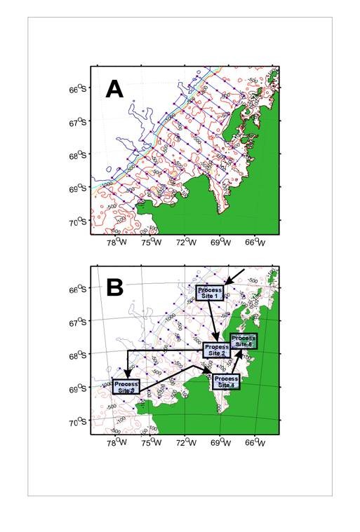
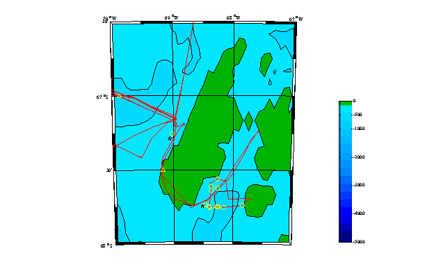
Figure 1. Survey and process study area
SO GLOBEC Marguerite Bay WAP.
RV Laurence M Gould 18 March 13 April
The L M Gould departed Punta
Arenas on 18
March 2001 with the objective of deploying a series of cetacean
passive acoustic and oceanographic moorings in the area off the year round
SO GLOBEC study site at MargueriteBay
(Figure 2).
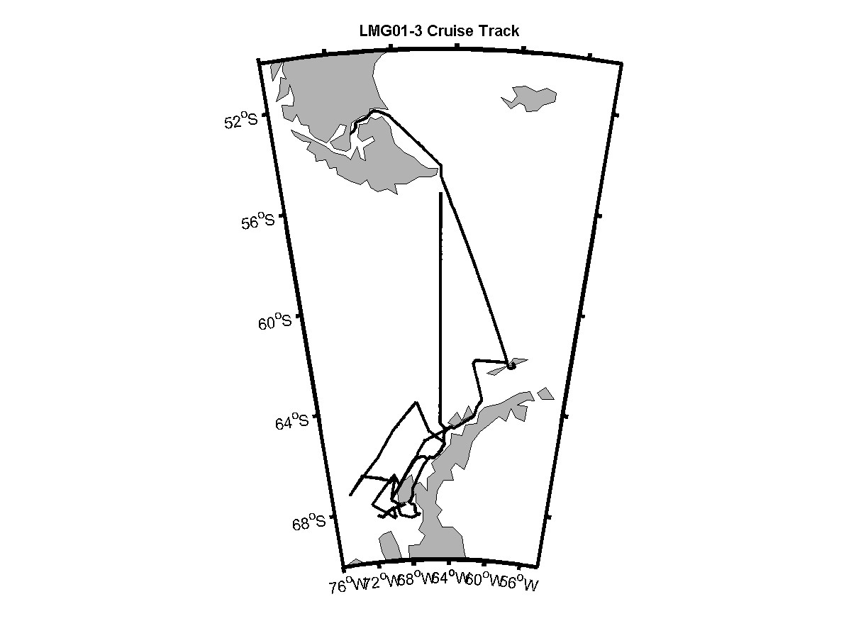
Figure 2. LMG01-3 cruise track
Methods visual survey, biopsy and photo identification
Visual survey for cetaceans was conducted on
LMG
01-03 during daylight hours on all days when weather conditions allowed.
Searching was conducted by the IWC observer (D Thiele) and Sue Moore with
assistance from the rest of the acoustic mooring team. Sightings were recorded
on a laptop based Wincruz
Antarctic program which also logged gps position, ship course and speed
automatically. Seals, seabird concentrations, ice concentration, sea surface
temperature, marine debris, sonobuoy deployments, depth and other events
were also recorded on the program. Survey effort generally commenced at
first light from the outside bridge wings and/or inside the bridge (weather
dependent) and ceased at dark. All times noted here, and in cruise records
refer to UTC/GMT not local time.
Results visual survey, biopsy and photo identification
Visual surveys alone were conducted from 19 March
to 2 April during the oceanographic and acoustic mooring components of
the cruise. Many humpback whales (Megaptera novaeangliae) were observed
during the afternoon transit across the BransfieldStrait
on 23 March. Five days of ship time were allocated to conduct cetacean
survey (including closing on sightings, biopsy, photo identification and
sonobuoy deployment) from first light on Tuesday 3 April to end of day
Saturday 7 April. The weather improved markedly for this part of the survey.
During this time the ship traversed the inside channels from the northern
end of Renaud Island, Grandidier Channel, Crystal Sound, Matha Strait and
passages to the east of Adelaide Island and the north-eastern section of
Marguerite Bay (Figures 2 and 4). Figure 4.a, b show the Western
Antarctic Peninsula and MargueriteBay
study area with LMG 01-03 cetacean sightings.
In MathaStrait
two large feeding groups of the dark shouldered minke whale (Balaenoptera
acutorostrata bonaerensis) were sighted (total of 80 animals). Photographs
were obtained and biopsies of four minkes from the largest group were taken.
On entering the northern end of MargueriteBay,
just near Rothera Station (UK), a large group (30)
of killer whales (Orcinus orca) were sighted. The killer
whales broke into sub-groups and travelled north past the ship with many
accompanying fur seals, and a minke whale (Balaenoptera acutorostrata).
One humpback (Megaptera novaeangliae) was also seen in the vicinity.
The ship took a south west course to NenyIsland
and then headed across the bay and towards Palmer Station on a course close
to the coast and inside the islands from MathaStrait
onwards. Two pairs of humpbacks were located late in the afternoon of the
7th April, with photo identification and biopsy obtained from
one pair. Total biopsies taken: 5 minke (one from a group of 7, and 4 from
the feeding group of 50) and 5 humpback
(one from one pair and both animals from another two pairs). A summary
of the biopsy samples is included at Table 2.
Methods and sonobuoy recordings - passive acoustics
The long-term nature of seafloor recorder deployments
allows for a statistically significant number of acoustic encounters, even
with a widely dispersed whale population, assuming whales call roughly
ten to fifty percent of the time.The
recordings will likely also include sounds from minke, right, fin and humpback
whales.Mysticete whales will be
detected via reception of their calls on passive, bottom-mounted acoustic
recorders.Detection of whale calls
via moored passive acoustic recorders has proven quite effective during
recent studies, especially for blue and fin whales.New technology,
that of long-term deployments of autonomous low power recorders
makes an acoustic survey of mysticete whales in remote locations practical.Deep
water is desirable partly because the ambient noise, which largely is produced
at the surface, is reduced at depth and also because acoustic travel paths
will interact less with the seafloor which absorbs acoustic energy.The
long-term nature of seafloor recorder deployments allows for a statistically
significant number of acoustic encounters even with a widely dispersed
whale population, assuming whales call roughly ten to fifty percent of
the time.
Given the great uncertainty in the numbers of blue
whales in the Southern Ocean, and in the subspecies to which they belong,
we believe the minimum census estimates which can be provided by acoustic
monitoring is a key goal of the proposed project. Application of the techniques
of point transect theory to the results of the survey where each acoustic
contact is assigned a range should allow a minimum census estimate, the
primary factor which will remain to be answered from other combined visual
and acoustic data being the percent of whales calling during a time constant.
The second fundamental goal of this work will be minimum population estimates
and seasonal occurrence profiles for fin whales and humpback whales.Other
species such as minke whales and sperm whales may be detected, but are
expected to be so infrequent as to make population density estimates unreliable.
Perhaps the most important overall result of this work will be to establish
an acoustic detection baseline from which to measure future changes in
relative abundance of Southern Ocean mysticete whales.
We deployed eight seafloor acoustic recorders (Figure
3.), each with a hydrophone thatis
floated about 5 m above the seafloor.These
instruments will record continuously at 500 samples per second for fifteen
months, writing the data to 36 Gb of computer
hard drive in each instrument.The
recorders have a 16 bit dynamic range and are powered by lithium double
D size batteries, which are placed inside high tensile aluminum pressure
cases.The seafloor recorders use
a system of drop weights, Benthos glass balls and an acoustic release for
recovery. Throughout the cruise we deployed and recorded 36 directional
sonobuoys and two broadband sonobuoys both randomly and when whales were
sighted, as a means to record and thereby `groundtruth mysticete whale
calls in this remote region. Recordings were obtained from humpback, minke
and fin whales during the cruise.No
blue or right whales were sighted or heard during this cruise.
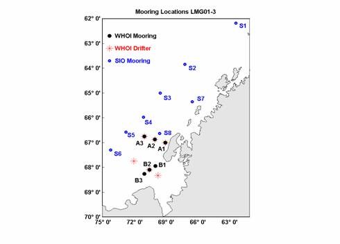
Figure 3. Locations of the moorings and
drifters deployed on LMG01-3 (SIO moorings are passive acoustic recorders).
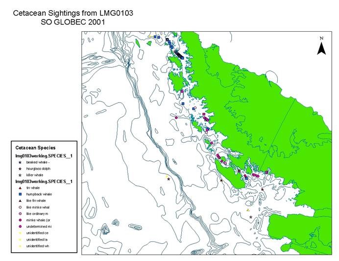
Figure 4.aLM
Gould 01-03 Mooring cruise - all cetacean sightings
Figure 4b L M Gould 01-03 minke and humpback sightings
General
This cruise was primarily an oceanographic and passive
acoustic mooring cruise. A series of oceanographic and passive acoustic
moorings were deployed on the shelf region off the MargueriteBay
study area (Figure 3.). These moorings will be retrieved during the 2002
mooring cruise and will provide important contextual data for the survey
and process study cruises on ocean current dynamics and cetacean presence/absence
and distribution throughout the period March 2001 to March 2002. IWC participation
was included on this cruise due to the opportunity to conduct visual surveys
in the area of mooring deployments. Expendable sonobuoys were also used
in conjunction with ship and zodiac based visual surveys, biopsy and photo
identification studies by the IWC team. During the cruise a block of five
days was allocated for the IWC work. Unlike the N B Palmer survey
cruise, the research on the L M Gould did not include an oceanographic
and biological sampling program (Limeburner et al 2001). However
associations between cetaceans and physical and biological features in
this area will be determined from existing models and data series held
by the US
program. Generally, the location of baleen whales was similar to that observed
on the N B Palmer, where comprehensive multidisciplinary sampling
revealed associations between the Antarctic Coastal Current, fronts between
major water bodies and upwelling zones.In
addition, survey of the passages between the continent and WesternPeninsulaIslands
to the north of and inside MargueriteBay
also revealed associations between baleen whales and cold water fronts
likely to be the result of mixing between warm and cold water as noted
in the N B Palmer summary (Figure 12.).
Polarstern
AntXVIII5b 14 April 7
May 2001
The Polarstern departed on cruise AntXVIII5b
on 14 April 2001
and headed directly for the SO GLOBEC study site (Figures 5. and 6.).
Figure 5. Polarstern AntVIII5b cruise track
and sampling stations
Most research work on the Polarstern has occurred
in the Weddell Sea,
however some research has been conducted in the WesternPeninsula
and BellinghausenSea
regions. Generally top predator studies on the Polarstern have been conducted
by J. van Franeker (with a focus on seabird abundance and associated cetacean
records), and some surveys have included cetacean visual surveys (Pankow
and Kock 2000). J. van Franeker conducted seabird census from the upper
bridge flying deck on the April May cruise, whilst the IWC observer worked
from the inside bridge. Helicopter surveys reported here were conducted
with JvF as he kindly shared his dedicated helicopter flight time for the
voyage with the IWC observer.
Weather conditions on this cruise were not conducive
to visual surveys, and few whales were sighted from the vessel. Most sightings
were made on the helicopter surveys (which were conducted in good weather
only) and on the one sunny day within the ice to the south of MargueriteBay.
The survey area was reached on 18 April and line transect sampling began
on a northern transect placed between those soon to be occupied by the
N B Palmer. The ship remained working in the survey area until 21
April, and then steamed to the oceanic fast ice edge well to the south
of MargueriteBay.
Figure 6. Polarstern AntVIII5b
cruise track and inset of Figure 8&9 with all cetacean sightings. Species
codes: 7=humpback yellow circle; 13&59=Lagenorhynchus sp. green
diamond; 4,91&92=minke black star; 9,64,65,67=unidentified
whale yellow triangle
Hourglass dolphins (1:10),
like fin (1:2) and an unidentified whale were recorded in the transect
area. The ship proceeded well within the ice to locate sea ice sampling
stations. At the first station on 23 April in a small lead near an iceberg
a group of four dark shouldered minke whales were sighted, and spent the
whole afternoon around the vessel whilst on station. This area, and the
area traversed through ice to reach it had 10/10 ice coverage and extensive
algal deposits on the underside of floes. On 24 Apriltwo
groups of minke whales (six animals were observed in the ice near the vessel).
On 25 April a series of helicopter flights were conducted to deploy sea
ice buoys and search for penguins, seals (JvF) and whales (DT). On take
off the usual 10/10 ice coverage could be seen to include a network of
leads and breathing holes similar to that reported in Thiele and Gill (1999).
Two groups consisting of three undetermined minke whales were sighted on
the survey routes mapped in Figure 7. Also depicted in this figure are
the sightings of minke and probable minkes recorded on a visual survey
along the cruise track whilst JvF conducted a helicopter survey ahead of
the vessel. The helicopter survey recorded only one minke, while the ship
based visual survey recorded 29 whales. These whales, either confirmed
as minke whales, or as like minke whales, were spread evenly over the shelf
area within 10/10 ice and were spaced fairly evenly throughout. Minke whale
presence stopped abruptly once the swell affected region of ice was reached,
coinciding with the shelf break.
Figure 7. Polarstern AntVIII5b in ice
cetacean sightings In ice helicopter surveys and ship based visual survey
25 & 26 April 2001.
Black star=minke; yellow triangle=probable minke. Bold red line
= cruise track. Fine red lines = helicopter surveys. Yellow line = oceanic
fast ice edge.
On 27 April the vessel left the ice and headed for
the GLOBEC study site to resume line transect survey and sampling. The
IWC observer was provided with helicopter time to conduct two further whale
flights whilst in the vicinity of AdelaideIsland
(Figure 8.) and AnversIsland.
The first of these surveys (1 May) covered an
route from the vessel on the western side of AdelaideIsland,
around the southern coast and then north to Rothera Station. The helicopters
then landed (to take equipment to Rothera). One helicopter was then used
to conduct a survey of the area to the south of the station. Large numbers
of humpback whales (20 in 10 pairs) were observed near JennyIsland,
a location where we had previously biopsied a humpback pair from the L
M Gould platform. One pair of humpbacks observed on the helicopter
flight was confirmed as a biopsied pair from the L M Gould cruise.
Some minke whales were also observed on this flight, and a
pair of humpbacks were seen feeding less than 1nm from the ship
on the return flight. The final helicopter survey was conducted on 2 May
off AnversIsland
to the north of the GLOBEC study site (near Palmer Station). On this short
(due to adverse weather) flight we surveyed the south western bays of AnversIsland,
observing pairs of humpbacks, and one group of four (with a large calf)
close inshore in separate bays. The humpbacks appeared to be spread along
these bays, and as this habitat extends to the north for some considerable
distance, it is likely that many more groups inhabited the unsurveyed bays.
The areas of concentration of both minke and humpback
whales coincide with those recorded on the N B Palmer cruise.
Figure
8. Polarstern AntVIII5b
cetacean sightings Adelaide Island/Rothera helicopter survey 1
May 2001. Yellow circle=humpback,
black start=minke. Bold red line = ship cruise track. Fine red lines =
helicopter survey tracks.
Nathaniel B. Palmer 01-03 24 April 6 June
The N B Palmer departed Punta Arenas on 24
April directly to the SO GLOBEC study area in order to commence the survey
cruise at the same time as the L M Gould (LMG 01-04) conducted
process studies in that area (Figure 1 a and b). The NB Palmer commenced survey
at the northern end of the line transect series shown in Figure
1.).
Methods visual survey, photo identification and biopsy
During this cruise, observations were made from
the ice tower or the bridge level by a single observer (AF).When
conditions permitted, the observer was outside along the cat-walk of the
ice tower, otherwise, observations were made from inside.Effort
was focused 45°
to port and starboard of the bow ahead of the vessel, while also scanning
to cover the full 180°
ahead of the vessel. °.
In ice the method was adjusted to include searching in behind the vessel
track as well, in order that cetaceans and seals hidden by ice would be
detected more readily. The observer used a combination of eye and binocular
(7x50 Fujinon) searching.Effort would
commence when the following conditions allowed: appropriate daylight, winds
less than 20 knots or Beaufort Sea State less than or equal to 5, visibility
greater than 1 mile (measured in the distance a minke whale blow could
be seen with the naked eye as judged by the observer) and the ship actually
steaming. Sightings were recorded on a laptop based Wincruz Antarctic program
which also logged gps position, course, ship speed, and a suit of other
environmental and sighting conditions automatically.Visual
observations were made both during the station-transect portion of the
trip, as well during transit.When
possible, photographic and/or video documentation was made of each sighting
for later use in individual identification, species confirmation, and habitat
description. A second component to the IWC work is biopsy sampling from
small boats.On the occasion that
weather conditions, daylight, timing, and whales were present, biopsy sampling
was attempted from Zodiacs.Samples
were obtained with a Barnett Wildcat Crossbow equipped with custom made
floating bolts, and screw-on hollow point biopsy plugs.
Results visual survey
Generally, sighting conditions during the cruise
were poor. However, nearly 80 hours (79:33) of sighting effort were made
during the entire cruise.Of this
time, 45:30 was made during the survey grid.In
Antarctic waters (south of 60°S),
43 cetacean sightings of 67 animals were made (Figure 9).
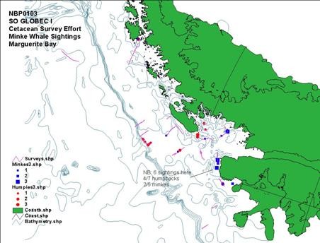
Figure 9. NBP
01-03 Cetacean Survey Effort Lines and Sightings in Antarctica
(below 60°S)
These include 19 sightings of 30 humpback whales,
Megapatera novaeangliae, 22 sightings
of 33 minke whales, Balaenoptera acutorostrata, 1 sighting of 3
like humpback whales, and 1 sighting of 1 unidentified whale (Table 1).
More specifically, within the study area as defined by the survey grid,
18 sightings of 27 humpback whales (Figure 10.), 19 sightings of 30 minke
whales (Figure 11.), 1 sighting of 3 like humpback whales, and 1 sighting
of 1 unidentified whale were made (Table 1.).
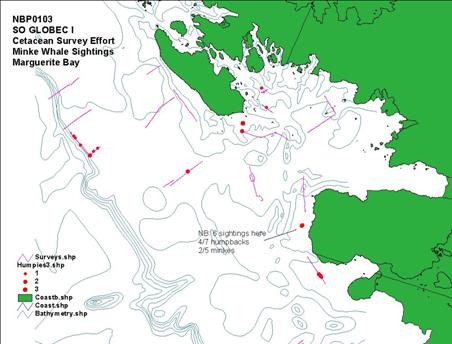
Figure10. NBP
01-03 Cetacean Survey Effort and Humpback Whale Sightings
Results sonobuoy, photo identification and biopsy
On the evening of 24 May,
sonobuoys recorded several humpback whales relatively close to the ship
(C. Berchock pers. comm.), and whales were seen in the ships lights as
the RVIB Nathaniel B. Palmer traveled north along the west coast of Alexander
Island. At first light the
ship was approximately 2 miles north of where the whales were seen. Ships
time was dedicated to biopsy sampling for the day in the area where the
whales were seen the previous day. At
0930 whales were sighted in an area with bands of brash ice several miles
off the coast. Weather conditions
were optimal for surveying and small boat work. In
the area of the ship (68.75S, 71.35W) were 3 pairs of humpback whales and
one single humpback whale, one group of 2 minke whales and one group of
3 minke whales. The whales appeared
to be tracing back and forth, perpendicular to the coast in a 2-3 mile
area. Photo-ID pictures were
taken of each
of the whales in the area, except 2 minkes and one humpback that were not
approached. Video footage of
the approach, biopsy shot and behaviour were taken. Biopsy
samples were obtained from 3 humpback whales and 1 minke whale. Only
one sample was taken from each group of animals approached. Skin
samples were taken from all 4 whales, while blubber samples were taken
from 2 of the humpbacks and the minke whale (Table 2).
General
A primary research objective of the cetacean studies
within SO GLOBEC is to determine the winter distribution and foraging ecology
of baleen whales in relation to the characteristics of the environment
and the distribution of their prey. Sightings data from this cruise recorded
only humpback (Megaptera novaeangliae) and minke (Balaenoptera
acutorostrata) whales present in the study region in the austral fall
and winter, suggesting that both over-winter around Marguerite Bay.Correlation
of cetacean distributions with concurrent hydrographic distributions (Figures
9., 10., 11., 12.) show whales associated with: 1) the southern boundary
of the Antarctic Circumpolar Current, 2) the frontal boundary between intrusions
of warm Upper Circumpolar Deep Water and continental shelf water, and 3)
the frontal boundary between inner shelf coastal current (Antarctic Coastal
Current) and continental shelf waters (E. Hofmann pers. Comm., Figure 13.).Cetacean
sightings were particularly numerous along the frontal boundary formed
as the coastal current exits the southern end of MargueriteBay.Humpback
whales were associated with all three frontal boundaries while minke
whales were found only along the continental shelf and coastal frontal
boundaries.The correspondence between
the cetacean sightings and hydrographic features suggests that the austral
winter distribution of cetaceans along the west Antarctic
Peninsula is not random, but rather is determined by the structure
of the physical environment, which in turn determines prey distribution.Continued
analyses and collection of cetacean sightings data in conjunction with
concurrent prey and hydrographic distributions will allow determination
of the causal relationships underlying austral winter cetacean distributions
in the Antarctic Peninsula region. This
survey cruise included a comprehensive suite of physical and biological
programs and an extensive range of scientific equipment in order to carry
out both fine and larger scale studies (ie. biomapper, ctd, echosounders,
net sampling, ROV, primary productivity etc..).
It is one of the most comprehensive multidisciplinary cruises ever conducted
in the Southern Ocean and provides the IWC with access to a well planned
cruise and analysis process of enormous scope and potential.

Figure 11. NBP 01-03 Cetacean Survey Effort
and minke whale sightings
Preliminary results from NB Palmer 01-03 on adult
krill distribution and migration in Antarctic autumn with implications
for baleen whale winter strategies and feeding ecology
One of the major objectives of all krill related studies
in the Southern Ocean has involved the determination of over wintering
strategies for this species which at present are unknown. In 1986 Kawaguchi
et al. suggested that krill were benthopelagic animals which probably
migrated to the sea floor during autumn and winter. However, they had no
quantitative data to support this hypothesis. Siegel and Kalinowski (1994)
speculated on a seasonal migration of krill across shelf areas, with this
autumn/winter migration possible related to the food gradient across the
shelf (ie. that benthic food sources may be the key to overwinter survival).
Later, Gutt and Siegel (1994) reported benthopelagic krill aggregations
at the shelf edge in the southeastern Weddell Sea
which they observed directly along transects using a video camera mounted
on a ROV. The observations were made at depths of 480 and 416m from a distance
of up to 200cm above the bottom. At one station a swarm was observed to
reach densities of several tens to several hundreds of specimens per m3,
maximum density exceeded 230 specimens per m3.
was then followed up by observations
by Gutt and Siegel (1994).
During the N B Palmer survey cruise (and on
Polarstern line transects) predominantly larval krill were found
on the outer shelf and oceanic regions of the study area. Adult krill were
for the most part only observed in near-shore shoal areas with widely varying
(complex) topography (refer to Fig 28.US SO GLOBEC Technical Report #2,
Wiebe et al. 2001). Basically the adult krill were observed aggregated
in holes among the peaks in a complex sea floor. These areas of krill concentration
occurred off the northern portion of AlexanderIsland
and the southern end of AdelaideIsland.
These coincide with baleen whale concentration sites recorded in autumn
and early winter on the 2001 cruises. The presence of aggregations of adult
krill inshore from the shelf is interesting because, if this autumn winter
pattern is shown to be widespread in MargueriteBay
and similar areas, then an overwinter food source is potentially available
to baleen whales. In the past it has been reported that all baleen whales
(except minkes as reported in Thiele and Gill, 1999) migrated out of the
Antarctic once the summer feeding season ended. The July to September
2001 winter survey by the N B Palmer (NBP 01-04) and data from the
passive acoustic moorings will help determine whether baleen whales remain
in this region of the Antarctic; whether they are feeding during the autumn
and winter; and what prey they are consuming. It may well be that while
the majority of baleen whales depart the rich Antarctic feeding grounds
in early autumn, in some areas some portion of populations of baleen whales
may remain throughout the winter, supported by adult krill concentrations
which appear to be located in direct association with well defined oceanographic
and bathymetric features.
Acknowledgements
We are extremely grateful
to Captain Warren Sanamo; his crew; Skip, Jenny, Jonnette and Andy from
the Raytheon marine support team; and the oceanographic science team from
the L M Gould, all of whom were responsible in some way for providing us
with five days of ship time and the opportunity to conduct biopsy and photo
identification from zodiacs throughout that period. We also thank them
for their enthusiasm and happy, professional attitude. All of the above
applies equally to the Captain, crew, marine support and science teams
on the N B Palmer, who provided similar opportunities and support on the
major survey cruise. Thanks also to Mark Christmas, National Geographic
Society for providing video footage of whale biopsy approaches on the NB
Palmer. We are extremely grateful to Eileen Hofmann, who has driven much
of the effort to have the IWC included in the SO GLOBEC effort; and to
John Hildebrand who included the IWC in the berth allocations for his program,
long before our participation could be assured. Thanks must also go to
the Captain and crew of the Polarstern, the cruise leader Uli Bathmann,
the Alfred-Wegener Insititute, and to Jan van Franeker and Martin Doble
for sharing their helicopter time with the IWC, sharing data and helping
with mapping.
References
Franklin, J. F., Bledsoe,
C. S., Callahan, J. T. 1990. Contributions of the
Long-Term Ecological Research Program. Bioscience 40 (7): 509
523.
Gutt, J.
, Siegel, V. 1994. Benthopelagic aggregations of krill on the deeper
shelf of theWeddell Sea (Antarctic) Deep Sea Research
I Vol 41 No. 1: 169 178.
Haskell, A. G. E., Hofmann,
E. E., Klinck, J. M., Lascara, C. M. 2001. Lagrangian modeling studies
of the spatial dynamics of Antarctic krill (Euphausia superba). Submitted
to Journal of Marine Research April 2001.
Hofmann, E. E., Klinck,
J. M., Lascara, C. M., Smith, D. A. 1996. Water
mass distribution and circulation west of the Antarctic
Peninsula and including BransfieldStrait.
Foundations for Ecological Research West of the Antarctic
Peninsula, Antarctic Research Series 70: 61 80.
Hofmann,
E. E., Lascara, C. M. 2000.Modeling the growth
dynamics of Antarctic krill Euphausia superba. Marine Ecology
Progress Series 194: 219 231.
Hofmann, E. E., Reilly,
S. 2000. An invitation for the IWC to participate
in Southern Ocean GLOBEC.SC/52/E22. Unpublished
paper submitted to IWC SC 52.
Kawaguchi,
K., Matsuda, O., Ishikawa, S., Naito, Y. 1986.The
overwintering strategy of Antarctic krill under the coastal fast ice off
the OngulIsland
in Lutzow-HolmBay, Antarctica.Memoirs
of the National Institute of Polar Research Tokyo
Special Issue 44: 67-85.
Limeburner, D. et al.
2001. RV Laurence M Gould Cruise 0103 to the Western Peninsula of Antarctica
US SO GLOBEC Report available on web site.
Pankow,
H., Kock, K-H. 2000. Results of a sighting survey in the Antarctic
Peninsula region in November December 1996. SC/52/E23.
Unpublished paper submitted to IWC SC 52.
Prezelin, B. B., Hofmann,
E. E., Mengelt, C., Klinck, J. M. 2000. The linkage
between Upper Circumpolar Deep Water (UCDW) and phytoplankton assemblages
on the west Antarctic Peninsula
continental shelf. Journal of Marine Research 58: 165 202.
Reilly,
S., Hedley, S., Hewitt, R., Leaper, R., Thiele, D., Pitman, R. L., Naganobu,
M., Watkins, J., Holland,
R. 2000. SOWER 2000: initial
results from the IWC-CCAMLR program to study whales and krill in the Southern
Ocean. unpublished paper submitted to IWCSC
52.International Whaling Commission Scientific Committee June 2000, Adelaide,
SC/52/E21.
Siegel,
V., Kalinowski, J. 1994 in Southern Ocean Ecology: The Biomass Perspective. El-Sayed,
S. Z. (ed.) CambridgeUniversity
Press.
Thiele,
D., Gill, P. C. 1999. Cetacean observations during a winter voyage into
Antarctic sea ice south of Australia.
Antarctic Science 11 (1), 48-53.
Thiele, D., Chester,
E. T. 2000. Ecological research and baleen whale management: a case study
from the Southern Ocean. Unpublished paper submitted to the International
Whaling Commission Scientific Committee June 2000, Adelaide, SC/52/E9.
Wiebe, P. et al.
2001. RVIB Nathaniel B. Palmer Cruise 0103 to the Western Peninsula of
Antarctica US SO GLOBEC Report available on web site.
Reports:
LMGould 01-03 1stcruise
(mooring cruise) - US Southern Ocean GLOBEC Report No.1
NBPalmer 01-03 1stcruise(survey
cruise)- US Southern Ocean GLOBEC Report No.2
LMGould 01-04 2ndcruise
(process cruise) - US Southern Ocean GLOBEC Report No.3
Web site for IWC cetacean
summaries by cruise, cruise reports, and technical US
SO GLOBEC reports:
http://www1.npm.ac.uk/globec/this
site provides a direct link to the CCPO site by clicking on SO GLOBEC
Table
1. Total cetacean sightings and number of animals in Antarctic waters
(south of 60°S)
for 2001 SO GLOBEC cruisesLMG
01-03 18 March 13 April 2001, Polarstern AntXVIII5b 14 April
7 May 2001, and NBP 01-03 24 April 6 June
|
Species
scientific name
|
Species
code
|
Total
sightings:animals
LMG
01-03 |
Total
sightings:animals
Polarstern
AntXVIII5b |
Total
sightings:animals
NBP 01-03
|
Species common
name
|
|
Balaenoptera
physalus
|
2
|
1:3
|
|
|
Fin whale
|
|
Balaenoptera
acutorostrata bonaerensis
|
4
|
9:91
|
5:13
|
|
Minke (ordinary
dark shoulder)
|
|
Like Balaenoptera
acutorostrata
|
92
|
5:14
|
27:30
|
|
Like minke
|
|
Lagenorhynchus
cruciger
|
13
|
1:4
|
1:10
|
|
Hourglass dolphin
|
|
Unidentified
cetacean
|
16
|
1:1
|
|
|
Unidentified cetacean
|
|
Undientified
large baleen whale
|
64
|
|
|
|
Unidentified large
baleen whale
|
|
Unidentified
large whale
|
67
|
3:5
|
1:1
|
|
Unidentified large
whale
|
|
Orcinus orca
|
10
|
4:53
|
|
|
Killer whale
|
|
Ziphiidae
|
11
|
2:5
|
|
|
Ziphiid
|
|
Like Megaptera
novaeangliae
|
71
|
|
|
1:3
|
Like humpback whale
|
|
Megaptera novaeangliae
|
7
|
38:81
|
16:38
|
19:30
|
Humpback whale
|
|
Megaptera novaeangliae
and like Balaenoptera physalus (mixed group)
|
7 and 91
|
1:12
|
|
|
Humpback whale and
like fin whale (mixed group)
|
|
Undetermined
Balaenoptera acutorostrata
|
91
|
18:40
|
7:11
|
22:33
|
Undetermined minke
whale
|
|
Like Balaenoptera
physalus
|
66
|
1:3
|
1:2
|
|
Like fin whale
|
|
Unidentified
small baleen whale
|
65
|
|
1:1
|
|
Unidentified small
baleen whale
|
|
Unidentified
whale
|
9
|
4:4
|
|
1:1
|
Unidentified whale
|
|
Total
|
|
88:316
|
59:106
|
43:67
|
Total
|
Table
2.
Cetacean biopsy samples LMG 01-03 and NBP 01-03 cruises
Date
|
3 April 2001
|
4
April 2001
|
4
April 2001
|
5
April 2001
|
7
April 2001
|
25 May 2001
|
25 May 2001
|
25 May 2001
|
25 May 2001
|
|
Latitude
(S)
|
66 02.15
|
66 40.41
|
66 41.38
|
67 42.90
|
65 34.44
|
68.75
|
68.75
|
68.75
|
68.75
|
|
Longitude
(W)
|
65 46.27
|
67 24.53
|
67 26.27
|
68 09.19
|
64 54.99
|
71.35
|
71.35
|
71.35
|
71.35
|
|
Unique
Id
(WS#) |
LMG 01-03#51
|
LMG 01-03#57
|
LMG 01-03#60
|
LMG 01-03#73 A + B
|
LMG 01-03#85 A + B
|
NBP 01-03#34
|
NBP 01-03#35
|
NBP 01-03#37
|
NBP 01-03#36
|
|
Species
|
2
|
1
|
1
|
2
|
2
|
2
|
2
|
2
|
1
|
|
Group
size
|
2
|
7
|
50
|
2
|
2
|
2
|
2
|
2
|
3
|
|
No.
animals sampled
|
1
|
1
|
4
|
2
|
2
|
1
|
1
|
1
|
1
|
|
photo
id
|
Y
|
Y of group
|
Y of group
|
Y
|
Y
|
Y
|
Y
|
Y
|
Y
|
Species
1 = minke dark shoulder form
Species
2 = humpback