Atmospheric and Oceanic Interactions Data
for Use With NASA Image2000
RETRIEVING DATA
Allows you to access the data for the tutorial and exercises
FOR FURTHER STUDY
Points you to sources of additional data related to this module
SATELLITE DATA INFORMATION
Gives information on the satellite instrument and the data used in this module
Before you begin retrieving data, be sure NASA Image2000 software is installed on your computer.
RETRIEVING DATA
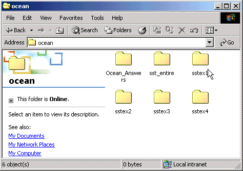
Data for the exercises have been compressed into a single archive of Zip files. To extract the Zip archive using WinZip, click on the file called sstex_i2k.zip below. Follow WinZip's instructions for extracting an archive. When the download is complete and the archive is unpacked, you'll see the following folders and files inside a folder called ocean.
Drag that folder into the "Data" folder in your Image2000 folder.
NOTE: In order to be able to follow the step-by-step instructions given in the exercises, be certain to extract the data files into the correct navigational path, as follows:
<i2k installed>|data|SEES|ocean|<exercise number>|<file name>
The folder entitled "Ocean_Answers" is empty -- it was intended as a placeholder only. Answers to the questions in the exercises are contained in the Instructor's Guide.
FOR FURTHER STUDY
Once you're comfortable with the concepts presented in the exercises and have mastered the software, explore the entire SST data set (sst_entire) more fully. After all, you have almost 20 years of monthly mean SST images right here on this Web site. Complete the same exercises using other images or sequences of images.
In addition to the global, monthly mean SST data set provided on this Web site, a high-resolution regional data set is available for use with NASA Image2000. Monthly mean high resolution images are available for the western North Atlantic Ocean, the Gulf of Mexico, the eastern and western Pacific Oceans, and the Indian Ocean. Apply the Image2000 tools you mastered on a particular region of the world's oceans. These data can be found at
http://www.ccpo.odu.edu/~lizsmith/SEES/Ocean_Circulation/SST/Data/regional/
Other sources of satellite-derived SST data abound. Although not formatted for use with Image2000, the images found at these sites will be superior examples of SST and suitable for class discussion. Here are a few of the most user friendly archives:
- Jet Propulsion Laboratory Physical Oceanography, Distributed Active Archive Center
http://podaac.jpl.nasa.gov
- National Oceanic and Atmospheric Administration (NOAA)
http://www.noaa.gov
- NOAA's CoastWatch Program
http://psbsgi1.nesdis.noaa.gov:8080/NSORS/ML/nsors1.html
SATELLITE DATA INFORMATION
Information on the satellite data is included in Part 2 of the Oceanography: Sea Surface Temperature lecture in the Class Resources component of this module.
| Home | Stratospheric Ozone | Global Land Vegetation | Oceanography | Polar Sea Ice Processes |