
The purpose of this section is to present the Nimbus-7 mission objectives, the scientific objectives of the Nimbus-7 experiments and to describe the TOMS instrument.
1.1 Nimbus-7 Mission
1.2 Nimbus-7 Scientific Objectives
1.3 Experiments
2.1.1 Attitude Control Subsystem
2.1.2 Instrument Power
2.2 Total Ozone Mapping Spectrometer (TOMS)
2.3 Scientific Objective
2.4 Instrumentation
2.4.1 TOMS Subsystem
2.4.2 Operating Modes
2.4.3 Electronic System
The Nimbus Program has provided valuable research techniques to collect global data on the environment of Earth. The seven Nimbus satellites have served as research platforms for 48 experiments to survey the atmosphere of Earth, map land and water characteristics, and observe weather and climate patterns. Advanced operational satellites now in use for weather and land observations include instruments and systems based on Nimbus designs.
Data gathered during Nimbus missions are used worldwide to determine the complex processes affecting man's environment. The Nimbus Program has proven vital to the advancement of the sciences of meteorology, climatology, oceanography, geology, geography, and hydrology.
The Nimbus-7 Mission was the single most significant source of experimental data from Earth's orbit relating to atmospheric and oceanic processes. It included eight experiments that provided a wealth of global data on the state of the atmosphere, snow and ice, the interaction between the oceans and the atmosphere, and on resources in the oceans. The data are measurements of the content of the oceans, the type and amount of radiation interacting with the atmosphere and the surface of Earth, and the content of the atmosphere. Nimbus-7 data sets provide a long-term view of the variations in the climate of Earth. All data were validated and archived for use by the scientific and commercial communities.
The Nimbus-7 spacecraft was launched from the Western Test Range at Vandenberg Air Force Base, California, by a thrust-augmented Delta vehicle on October 25, 1978; measurements began about a week later. The satellite was placed in a 955 kilometer, sun-synchronous polar orbit, having local noon (ascending) and midnight (descending) equator crossings, with 26.1° of longitude separation. The orbital period was about 104.16 minutes. A given point on Earth was viewed twice a day, once in sunlight and once in darkness. This orbit allowed the Nimbus-7 experiments to measure the surface or atmospheric events on a global scale, revealing features not observable from the surface of Earth.
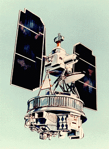
In orbit, with its solar panels unfolded, the Nimbus-7 was a butterfly shaped satellite, with a sensory ring at its base, containing the experiments and supporting subsystems. The earth-viewing sensors are mounted below the torus structure. The attitude control system and the solar array are supported above the torus by a truss. The Nimbus-7 satellite weighs 965 kilograms (2176 pounds). When in orbit, the Satellite experiment pointed toward Earth to an accuracy of 1 degree via an active attitude control subsystem.
The Satellite communication subsystem (including transponders, antennas, tape recorders, and data processing equipment) recorded, stored, and transmitted experiment observations and satellite/experiment "housekeeping" data to the ground. It also provided for spacecraft tracking.
Ground operations for Nimbus-7 were centralized at NASA GSFC. Various remote facilities throughout the world tracked the Satellite and received or processed data. The NASA Spaceflight Tracking and Data Network (STDN) tracked the Satellite and received the data. The NASA Communication Network transmitted the data from the receiving sites to GSFC. GSFC performed the initial processing of the data from all eight experiments.
1.2 Nimbus-7 Scientific Objectives
Nimbus-7, the last in the Nimbus series of satellites, observed Earth in a wider range of the electromagnetic spectrum that its predecessors. Also, it provided data sets of unprecedented weather, climate, water, and the surface of Earth.
The Nimbus-7 mission afforded the opportunity to conduct a variety of experiments in the pollution, oceanographic and meteorological disciplines. It provided an opportunity to assess each instrument's operation in the space environment and to collect a sizable body of data with the global and seasonal coverage needed to support each experiment. This mission also extended and refined the sounding and atmospheric structure measurement capabilities demonstrated by experiments on previous Nimbus observatories. The mission objectives of the Nimbus-7 were:
*To observe gases and particulates in the atmosphere for the purpose of determining the feasibility to map sources, sinks, and dispersion mechanisms of atmospheric pollutants (SBUV/TOMS, SAM II, SAMS, LIMS)
*To observe ocean color, temperature, and ice conditions, particularly in coastal zones, with sufficient spatial and spectral resolution to determine the feasibility of application such as:
(a) detecting pollutants in the upper level of oceans,
(b) determining the nature of materials suspended in the water,
(c) applying the observations to the mapping of sediments, biologically productive areas, and interactions between coastal effluents and ocean waters (CZCS),
(d) demonstrating improvements in ship route forecasting (SMMR).
*To make quantitative measurements of air-surface boundary conditions (e.g., soil moisture, snow and ice cover, sea surface temperature and roughness, and albedo) or of precipitation, and to improve long-range weather forecasting in support of the Global Atmospheric Research Program (SMMR, ERB)
*To continue to make baseline measurements of variations of long wave radiation fluxes outside the atmosphere and of atmospheric constituents for the purpose of determining the effect of these variation on Earth's climate (ERB, SBUV/TOMS, LIMS)
Seven experiments and one subsystem (THIR) were on board the Nimbus-7 spacecraft. These experiments and a brief description of their scientific objectives are presented here:
Coastal Zone Color Scanner (CZCS). The objective of the CZCS was to map chlorophyll concentration, sediment distribution, gelbstroffe concentrations as a salinity indicator, and temperature of coastal waters and the open ocean.Earth Radiation Budget (ERB). An instrument very similar to the ERB of Nimbus 6 determined over a period of one year the radiation budget of the earth on both synoptic and planetary scales by simultaneous measurement of incoming solar radiation and outgoing earth reflected (short wave) and emitted (long wave) radiation. Both fixed wide angle sampling of terrestrial fluxes at the satellite altitude, and scanned narrow-angle sampling of the radiance components, dependent on angle are used to determine outgoing radiation.
Limb Infrared Monitor of the Stratosphere (LIMS). The objective of LIMS was to obtain vertical profiles and maps of temperature and the concentration of ozone, water vapor, nitrogen dioxide, and nitric acid for the region of the stratosphere bounded by the upper troposphere and the lower mesosphere.
Stratospheric Aerosol Measurement II (SAM II). The SAM II objective was to map the concentration and optical properties of stratospheric aerosols as a function of altitude, latitude, and longitude. When no clouds are present in the instrument's instantaneous field of view (IFOV), the troposphere aerosols can also be mapped.
Stratospheric and Mesospheric Sounder SAMS). The SAMS objective was to observe the limb of the atmosphere through various pressure modulator radiometers in order to measure vertical concentrations of H2O, CH4, CO, and NO; observe resonant scattering of solar radiation in spectral bands H2O, CO2, CO, and NO; measure the temperature of the stratosphere and mesosphere to ~90 kilometers altitude; investigate source function and departure from the thermodynamic equilibrium between 80 and 130 kilometers associated with CO2 emission bands, and measure the zonal wind velocity component along the line of sight.
Solar Backscatter Ultraviolet/Total Ozone Mapping (SBUV/TOMS). The SBUV/TOMS objectives were to determine the vertical distribution of Ozone, map the total ozone and 200 mb height fields, and monitor the incident solar ultraviolet irradiance and ultraviolet radiation backscattered from Earth.
Scanning Multichannel Microwave Radiometer (SMMR). The primary purpose of the SMMR was to obtain and use ocean momentum and energy-transfer parameters on a nearly all-weather operational basis. Derived low altitude parameters are winds, water vapor, liquid water content, and mean cloud droplet size.
Temperature Humidity Infrared Radiometer (THIR). The primary objective of the THIR was to measure the infrared radiation from Earth in two spectral bands during both day and night portions of the orbit; to provide pictures of the cloud cover, three-dimensional mappings of cloud cover, temperature mappings of clouds, land, and ocean surface, cirrus cloud content, atmospheric contamination and relative humidity.
The Nimbus-7 spacecraft components, consisting of the integrated subsystems that provide the power, attitude control, and information flow required to support the payload for a period of one year in orbit, are contained within the three major structures of the spacecraft. These three structures consist of: a hollow torus shaped sensor mount, the solar paddles, and a control housing unit that is connected to the sensor mount by a tripod truss structure.
The spacecraft had a configuration similar to an ocean buoy. It was 3.04 meters tall, 1.52 meters in diameter at the base, and 3.6 meters wide with the solar paddles fully extended. The sensor mount that formed the satellite base housed the electronics equipment and battery modules. The lower surface of the torus provided mounting space for sensors and antennas. A box-beam structure mounted within the center of the torus provides support for the larger sensor experiments. The control housing unit was located on top of the spacecraft and above this unit are the sun sensors, horizon scanners, and a command antenna.

2.1.1 Attitude Control Subsystem
The attitude control subsystem (ACS) provides stabilization about the spacecraft's roll, pitch, and yaw axis and control of the solar paddles orientation, maintaining them nearly perpendicular to the nominal sun line.
The ACS consists of four attitude control loops and associated switching logic, telemetry and test modes, electrical manifolding, and thermal environmental control. This system maintains spacecraft alignment with the local orbital reference axes to within 0.7 degree of the pitch axis and one degree of the roll and yaw axis. The system keeps the instantaneous angular rate changes about any axis to less than 0.01 degree per second.
The three-axis active ACS uses horizon scanners for roll and pitch attitude error sensing. The rate gyros sense yaw rate and, in a gyro compassing mode, sense yaw attitude. A torquing system uses a combination of reaction jets to provide spacecraft momentum control and large control torques when required; flywheels are utilized for fine control and residual momentum storage.
The spacecraft power subsystem consists of solar arrays, nickel-cadmium batteries, charge and discharge regulators, and voltage regulators to operate all spacecraft support subsystems and to provide maximum power for the instrument payload.
The orbit average regulated power provided by the observatory power subsystem was approximately 300 watts, of which 123 watts were allocated to the spacecraft subsystems. If all of the instruments were on full-time, the power requirements would exceed the available supply. Because of this power limitation, the subsystems would operate less than 100% of the time except for the THIR which operated on a full-time basis.
2.2 Total Ozone Mapping Spectrometer (TOMS)
The Total Ozone Mapping Spectrometer experiment on board the Nimbus-7 satellite provided daily global coverage of Earth's total ozone by measuring the back scattered Earth radiance in the six 1-nm bands in the following wavelength regions: 312, 317, 331, 340, 360, and 380. The experiment used a single monochromator and scanning mirror to sample the back scattered solar ultraviolet radiation at 35 sample points at 3° intervals along a line perpendicular to the orbital plane. The measurements used for ozone retrieval were made during the sunlit portions of the orbit as the spacecraft moved from south to north. In normal operation, the scanner measured 35 scenes, one for each scanner view angle, stepping from right to left. It then quickly returned to the first position, not making measurements on the retrace. Eight seconds after the start of the previous scan, another would begin.
For the first 7.5 months of operation, TOMS followed a regular ON/OFF schedule for spacecraft power management, operating on 10 of each 12 days. At times, the instrument was operated on scheduled OFF days also, thus resulting in an actual duty cycle greater that 83 percent. A relay malfunction prevented any measurements from being made during the 6-day period of June 14-19,1979. Starting June 22, 1979, TOMS operated full time. Early in 1984, a lack of synchronization between the TOMS wavelength selection/chopper wheel and the electronics began to develop. When this condition passed a defined threshold, the data were flagged. The frequency of this condition rarely exceeded 20 percent, except during summer 1990, when it reached 90 percent. However, evidence exists in the data for sporadic periods of less than a day when a subthreshold synchronization problem existed. The instrument failed on May 6, 1993.
The Solar Backscatter Ultraviolet and Total Ozone Mapping Spectrometer(SBUV/TOMS) experiment was an expanded and improved version of the Backscatter Ultraviolet (BUV) experiment on Nimbus 4, and is composed of two essentially independent instruments.
The Solar Backscatter Ultraviolet (SBUV) subsystem consists of a double Ebert-Fastie spectrometer and a filter photometer similar to the BUV. Both channels simultaneously view identical fields of solar radiation scattered by the terrestrial atmosphere in the nadir of the solar flux scattered from the instrument diffuser polar which is deployed on command. The spectrometer serially monitors 12 selected narrow wavelength bands in the spectral region from 250 nm to 340 nm, or continuously scans the wavelength range from 160 nm to 400 nm, while the photometer measures the light in a fixed band centered at 343 nm. This instrument is intended for use in determining the total ozone and its vertical distribution above the ozone maximum for measuring the ultraviolet solar spectral irradiance.
The Total Ozone Mapping Spectrometer (TOMS) subsystem employs a single monochromator whose IFOV is scanned through the subsatellite point and perpendicular to the orbital plane. The backscattered radiation is sampled at six wavelengths from 312.5 nm to 380 nm sequentially in three degree steps in the + 51 degrees cross scan from the nadir. This scanning creates a contiguous mapping of the total ozone since the scans of consecutive orbits overlap.
The polar orbit of this satellite made possible the ozone measurements on a global basis and the 14.5 years of lifetime permitted the long-term monitoring of ozone and the ultraviolet solar flux. Advances in the standard spectral irradiance sources used in the calibration provided better accuracy in the absolute solar flux measurement.
TOMS was designed to measure the solar ultraviolet radiation backscattered from Earth and its atmosphere. The scientific objective was to obtain contiguous global long term mapping of total ozone.
TOMS is a single Ebert-Fastie spectrometer with a fixed grating and an array of exit slits. TOMS has a 3o by 3o instantaneous field of view and measures six discrete wavelengths ranging from 312.5 to 380 nm with a 1 nm bandwidth. The phase lock loop is synchronous to the Nimbus clock frequency. The disk also serves as chopper to allow synchronous modulation of the optical signal. The TOMS light chopping frequency is 143 Hz. The wavelength selector disc also has a set of entrance slits for wavelength calibrations. A set of holes (exit slits for the 317.5 nm band)in the wavelength selector serve as a fixed exit during wavelength calibrations. A set of holes (exit slits for the 317 nm band) in the wavelength selector serve as a fixed exit during wavelength calibration.
TOMS is a cross-course scanning instrument. A scanning mirror scans across the track +51 degrees from the nadir in 3 degree steps. One complete cross scan takes eight seconds, including one second for retrace, while recording the data for 35 scenes. The encoder senses the position of the scan mirror on a six-bit code word which is telemetered to the ground with the scene data. At each scene during stepping, the chopper sequentially gates all six wavelengths four times such that the selected wavelengths are gated in succession and the order of gating is reversed in next sampling. The total time spent at each scene is 200 ms which includes 168 ms for six wavelengths data sampling and 32 ms for the scanner settling.
TOMS uses the same type of PMT as the SBUV, and has a separate mercury-argon lamp for wavelength calibration and a separate depolarizer. However, as noted above, TOMS shares the diffuser with the SBUV for solar irradiance measurement.
The TOMS scanner is length calibration and is stepped up to six degrees over a horizontal position during solar irradiance measurement to view the diffuser commanded to TOMS position.
The five scanner modes for TOMS are: scan off, single step, normal scan, stowed, and view diffuser.
In single step mode, the scanner stops and responds to actuation of the momentary relay connected to the TOMS single step command line. In normal scan mode, the scanner scans 35 positions, retraces to the first scene and starts another scan of 35 scenes.
In stowed mode, the scanner slews to the stowed position and stops. This mode is required for the TOMS wavelength calibration. In view diffuser mode, required in solar spectral irradiance measurement, the scanner slews to the view diffuser position and stops.
Each sensor module houses a detector power supply, the first stages of the signal processing, a calibration generator, and its own optical and mechanical systems. The calibration generator is a constant current source used for the in-flight electronic calibration. The electronics module accommodates all the supporting electronic circuits including the data processing and command logic.
The SBUV/TOMS has four data output channels: one for the monochromator, one each for the reference and the photometer for the SBUV, and one for the TOMS. The signal processing is very similar in each channel, though not identical. A distinct feature in the SBUV/TOMS detecting electronics compared to the original Nimbus 4 BUV experiment is the use of the optical chopper to eliminate the dark current contribution in the output by the up/down counting technique.
| Home | Stratospheric Ozone | Global Land Vegetation | Oceanography | Polar Sea Ice Processes |