
Global Vegetation Satellite and Sensor Information
The Advanced Very High Resolution Radiometer (AVHRR) instrument and associated platforms
Global Vegetation Satellite and Sensor Information
The Advanced Very High Resolution Radiometer (AVHRR) instrument and associated platforms
1.1 The TIROS-N and NOAA series of satellites
1.1.1 History
1.1.2 Instrument packages on the POES series
1.1.3 Satellite characteristics
1.1.4 Orbital information
1.2.1 Scientific objective
1.2.2 Instrument description
1.2.3 Future AVHRR instruments
This document was written to provide some detailed information about the satellites and sensors used in acquiring AVHRR imagery.
1.1 The TIROS-N and NOAA Series of Satellites
This section provides a history and description of the various properties of the satellites that carry the AVHRR instrument. All of the satellites are part of the NOAA Polar orbiting Operational Environmental Satellite (POES) series. NASA funded the development and launch of the first satellite but subsequent satellites were procured and launched by NASA using NOAA funds.
The AVHRR instrument was initially designed for meteorological applications. The goal was to develop a system that would provide a more efficient way to track clouds, estimate snow cover extent, and estimate sea surface temperature. It wasn't until a few years after the launch of the first AVHRR instrument that its usefulness in monitoring global vegetation became obvious.
All of the AVHRR sensors have been housed on the TIROS-N and NOAA-6 through NOAA-15 polar orbiting satellites. Starting with NOAA-8 this series of satellites is also referred to as the Advanced TIROS-N (ATN) series. To date, eleven such satellites have been launched. The first one, launched in 1978, was called the Television and Infrared Observation Satellite (TIROS-N). This was followed by the National Oceanic and Atmospheric Administration's (NOAA) NOAA-A satellite which was renamed NOAA-6 after its launch. Table 1 shows the dates and names of the various satellites which carry the AVHRR instrument.
Table 1 : NOAA POES Launch Dates
| Name after launch | Name before launch | Date of launch | ||
| TIROS-N | TIROS-N | October, 1978 | ||
| NOAA-6 | NOAA-A | June, 1979 | ||
| NOAA-7 | NOAA-C | June, 1981 | ||
| NOAA-8 | NOAA-E | March, 1983 | ||
| NOAA-9 | NOAA-F | December, 1984 | ||
| NOAA-10 | NOAA-G | September, 1986 | ||
| NOAA-11 | NOAA-H | September, 1988 | ||
| NOAA-12 | NOAA-D | May, 1991 | ||
| NOAA-13 | NOAA-I | August, 1993 | ||
| NOAA-14 | NOAA-J | December, 1994 | ||
| NOAA-15 | NOAA-k | February, 1998 |
1.1.2 Instrument Packages on the Polar Orbiting Observational Satellite Series
The TIROS-N and NOAA satellites 6 through 15 all carried at least two instrument packages. The first was the AVHRR which will be discussed in detail. The other package was the TIROS Operational Vertical Sounder (TOVS). TOVS is comprised of three sensors: Microwave Sounding Unit (MSU), Stratospheric Sounding Unit (SSU), and the High Resolution Infrared Radiation Sounder/2 (HIRS/2). TOVS was designed so that the data from the HIRS/2, SSU and MSU instruments could be combined to compute: 1) atmospheric temperature profiles from the surface to 10 millibars (mb), 2) water vapor content at three levels of the atmosphere, and 3) total ozone content. Another sensor, a Solar Backscattered Ultraviolet system (SBUV/2) for ozone measurement, was added starting with the NOAA-9 spacecraft. Incrementally added to the payload was a Search and Rescue Demonstration System (SAR), and an Earth Radiation Budget Experiment (ERBE) flown on NOAA-9 and NOAA-10 only.
1.1.2.1 Microwave Sounding Unit (MSU)
The MSU is designed to measure tropospheric temperature. It consists of a radiometer which make passive measurements of the 5.5µm wavelength region which is know as the oxygen band. The instrument measures energy from the troposphere to construct a vertical temperature profile to an altitude of about 20km.
1.1.2.2 Stratospheric Sounding Unit (SSU)
The SSU is designed to measure temperature profiles from altitude of 25km to 50km. It consists of a three channel radiometer which makes passive measurements of the wavelength region between 14.925µm and 14.939µm (a carbon dioxide absorption region).
1.1.2.3 High Resolution Infrared Radiation Sounder/2 (HIRS/2)
The HIRS/2 instrument has twenty channels which measure incident radiation primarily in the infrared region of the electromagnetic spectrum including both longwave (15 micrometer) and shortwave (4.3 micrometer) regions. This sensor has multiple functions. It measures the atmospheric temperature between the Earth's surface and 50mb, water vapor in three atmospheric layers, and total ozone.
1.1.2.4 Solar Backscattered Ultraviolet System (SBUV/2)
The SBUV/2 measures backscatter radiation in the 0.16-0.4µm range to determine ozone profiles, total atmospheric ozone, solar irradiance, and terrestrial radiances. The principle of operation is to measure backscattered solar energy in the ultraviolet (UV) region at 12 wavelengths positioned on the edge of the ozone absorption band. The shorter wavelengths are sensitive to high stratospheric ozone and the longer ones are sensitive to low stratospheric ozone. Since ozone absorbs radiation in the ultraviolet wavelengths, its concentration can be derived from the ratio of backscattered radiation to incident solar radiation.
1.1.2.5 Earth Radiation Budget Experiment (ERBE)
The ERBE instrument measures monthly and seasonal variations of radiation balance at regional scales, and the effect of clouds on the radiation budget. The ERBE instrument consists of non-scanning and scanning data collection subsystems. The non-scanner sensor has 5 channels. Four channels are looking at the earth with a nadir view, and a fifth channel is directed toward the sun. The scanner sensor has 3 channels. One channel isolates shortwave radiation, another covers longwave radiation, and the third channel provides total radiation measurements.
1.1.3 Satellite Characteristics
The TIROS-N series satellites (see figure 1 picture of the satellite) weigh about 1700 kilograms (about 3.7 U.S. tons). The dimensions of the satellites are 1.8 meters X 4.18 meters. The sensors are designed to last for two years although they typically last longer. Also onboard are solar panels which are designed to provide 1500 watts of power to the sensor and navigation systems.
Figure 1: Image of a NOAA POES
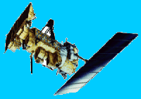
The spacecraft structure consists of four components: 1) the Reaction System Support Structure (RSS); 2) the Equipment Support Module (ESM); 3) the Instrument Mounting Platform (IMP); and 4) the Solar Array (SA). Instruments are located on both the IMP and the ESM. All the instruments listed above face the Earth when the satellite is in mission orientation.
Onboard the satellites are systems which can transmit the data and record the data so it can be stored and then transmitted at a later time. The TIROS Information Processor (TIP) formats data available for transmission from the satellite. It also controls the data outputs from these sources and accepts command verification data.
The on-orbit Attitude Determination and Control Subsystem (ADACS) provides three axis pointing control for the satellite. The ADACS maintains system pointing by controlling torque in three mutually orthogonal wheels (a fourth skewed wheel is available in the event of failure of one of these three). The torque is determined by analysis of spacecraft orientation in space. Input to these computations are acquired from the Earth Sensor Assembly (ESA) for pitch and roll, and an inertial reference with sun updates for yaw.
The ADACS is required to control spacecraft attitude so that orientation of the three axes is maintained to within plus or minus 0.2 degrees of the local geographic reference. Information to permit computation of yaw, pitch, and roll to within 0.1 degrees by computer processing on the ground, after the fact, is also available.
The TIROS-N series satellites were designed to operate in a nominal 833 or 870 Km circular, near-polar, sun-synchronous orbit. With this orbit, the satellites circle the Earth every 102 minutes, or 14.1 orbits per day which is sufficient to provide global coverage twice daily (normally a daytime and a nighttime overpass). The satellite does not follow the same track day-after-day, although the local solar time of the satellite's passage is essentially unchanged for any latitude.
The missions of the TIROS-N series satellites are designed to be either morning (AM) or afternoon (PM) missions. The AM missions are designed to pass the equator on their descending (North to South pass) at a local time of around 07:30 just after launch. The PM missions are designed to pass the equator on the ascending (South to North pass) at a local time of 13:30 to 14:30 just after launch. At any one time, there have been two or more of these satellites flying, each with a different equatorial crossing time, so that it is possible to have morning and afternoon data acquired of the same location in a single day. Over time, the satellite's orbit changes. This changes the local time of observation (the local time of the area that is being scanned). Fortunately, these changes are well documented and can be compensated for during processing.
The AVHRR instrument is the primary focus of this educational module on global vegetation. The instrument is not considered one of the more sophisticated remote sensing scanners flying today but the fact that it has been providing consistent global coverage of the Earth since 1978 makes it a valuable tool for consistent monitoring of global changes in vegetation.
The AVHRR was designed to measure cloud cover, day and nighttime sea surface temperature, cloud formations, and surface reflectance properties (from which vegetation indices were later derived). The objective was to fly this instrument in order to obtain contiguous global coverage on a daily basis.
The Advanced Very High Resolution Radiometer (AVHRR) is actually not that advanced by today's standards. Compared to many other environmental remote sensing sensors it does not provide high spatial resolution data. Compared to other satellites designed to measure meteorological phenomena, however, the spatial resolution of the AVHRR can be considered high. The AVHRR instrument has a reasonably high radiometric resolution. This means that the instrument can measure reflected and emitted energy with a higher precision than most other sensors. Energy recorded by the AVHRR instrument is given a value between 0 and 1023 as compared to most other sensors which record values between 0 and 255. This difference allows the AVHRR instrument to record finer differences in reflectance and emission.
The AVHRR is a scanning radiometer which uses five detectors that collect different bands of radiation wavelengths. The AVHRR scanner uses a mirror which allows it to collect data 55 degrees east and west of nadir (vertical). This gives a swath width of approximately 2600 kilometers. The data capture rate is such that one scan line (one swing of the mirror) is made up of 2048 pixels. The scanner has an instantaneous field of view (IFOV) of approximately 1.4 milliradians which produces a resolution of about 1.1 kilometers at nadir and expands to approximately 17 kilometers at its extreme angle of 55 degrees.
The instrument records data for five wavelengths as listed in Table 2. The first channel is in the orange and red portion of the spectrum and the second channel in the near infrared portion. These two channels are used to observe vegetation, clouds, lakes, shorelines, snow, and ice. The third channel is in the mid-infrared portion, however, it is located so that it detects a mixture of reflected and emitted energy. This channel is used extensively for detecting fires and other very hot objects. The last two channels are located in the far infrared region of the spectrum and are sensitive primarily to emitted thermal radiation. These two channels are used primarily to detect the surface temperature of sea and land. These last three channels are often used to identify clouds and calibrate the first two channels. The three IR channels are calibrated in-flight using a view of a stable blackbody and space as a reference. No in-flight visible channel calibration is performed.
Table 2: Wavelength Sensitivity for Each Channel of the AVHRR Sensors
|
|
|
|
-12,-14 |
|
|
|
|
|
|
|
|
|
|
|
|
|
|
|
|
|
|
|
|
|
|
|
|
|
|
|
|
|
|
|
1.2.3 Future AVHRR instruments
A new series of AVHRR instruments, known as AVHRR/3, commenced in 1998. A near infrared channel, know as channel 3A at 1.6µm, was added to operate during the daylight passes. The original channel 3 operates during nighttime passes. Changes were also made to make the first three channels more responsive to ice, snow, and aerosol detection.